
Hagerstown topographic map
Interactive map
Click on the map to display elevation.
About this map
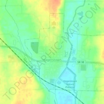
Name: Hagerstown topographic map, elevation, terrain.
Location: Hagerstown, Wayne County, Indiana, United States (39.90306 -85.17084 39.92317 -85.14325)
Average elevation: 312 m
Minimum elevation: 295 m
Maximum elevation: 335 m
Terrain surrounding Hagerstown consists of flat land at an elevation of roughly 1000 feet above sea level that is used primarily for agriculture.
Other topographic maps
Click on a map to view its topography, its elevation and its terrain.
Spring Grove
United States > Indiana > Wayne County
Spring Grove, Wayne County, Indiana, United States
Average elevation: 300 m
Boston
United States > Indiana > Wayne County
Boston, Wayne County, Indiana, 47324, United States
Average elevation: 344 m
Cambridge City
United States > Indiana > Wayne County
Cambridge City, Wayne County, Indiana, United States
Average elevation: 292 m
Richmond
United States > Indiana > Wayne County
Richmond, Wayne County, Indiana, 47374, United States
Average elevation: 314 m
Economy
United States > Indiana > Wayne County
Economy, Wayne County, Indiana, United States
Average elevation: 345 m