
Boston topographic map
Interactive map
Click on the map to display elevation.
About this map
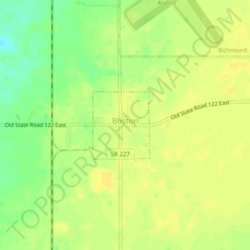
Name: Boston topographic map, elevation, terrain.
Location: Boston, Wayne County, Indiana, 47324, United States (39.73746 -84.85576 39.74478 -84.84777)
Average elevation: 344 m
Minimum elevation: 328 m
Maximum elevation: 351 m
Other topographic maps
Click on a map to view its topography, its elevation and its terrain.
Spring Grove
United States > Indiana > Wayne County
Spring Grove, Wayne County, Indiana, United States
Average elevation: 300 m
Cambridge City
United States > Indiana > Wayne County
Cambridge City, Wayne County, Indiana, United States
Average elevation: 292 m
Richmond
United States > Indiana > Wayne County
Richmond, Wayne County, Indiana, 47374, United States
Average elevation: 314 m
Economy
United States > Indiana > Wayne County
Economy, Wayne County, Indiana, United States
Average elevation: 345 m
Hagerstown
United States > Indiana > Wayne County
Hagerstown, Wayne County, Indiana, United States
Average elevation: 312 m