Geolocate

Chiang Mai Province topographic map

Interactive map

Click on the map to display elevation.

Chiang Mai Province

Chiang Mai province is about 685 km (426 mi) from Bangkok in the Mae Ping River basin and is on average at 300 m (1,000 ft) elevation. Surrounded by the mountain ranges of the Thai highlands, it covers an area of approximately 22,135 km2 (9,000 sq mi). The mountains of the Daen Lao Range (ทิวเขาแดนลาว) at the north end of the province, the Thanon Thong Chai Range (เทือกเขาถนนธงชัย) with the highest mountain in Thailand, Doi Inthanon at 2,565 metres (8,415 ft), stretching in a north–south direction, and the Khun Tan Range in the east of the province are covered by rain forest. The Mae Ping, one of the major tributaries of the Chao Phraya River, originates in the Daen Lao mountains. Several national parks are in the province: Doi Inthanon, Doi Suthep-Pui, Ob Luang, Sri Lanna, Huai Nam Dang, Mae Wang, and Pha Daeng. The total forest area is 15,404 km2 (5,948 sq mi) or 69.6 percent of provincial area.

Wikipedia (CC-BY-SA 3.0)

About this map

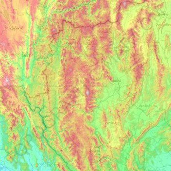
Name: Chiang Mai Province topographic map, elevation, terrain.

Location: Chiang Mai Province, Thailand (17.24833 98.08083 20.14758 99.57585)

Average elevation: 649 m

Minimum elevation: -1 m

Maximum elevation: 2,541 m

Other topographic maps

Click on a map to view its topography, its elevation and its terrain.

Chiang Mai

Thailand

Chiang Mai has a tropical savanna climate (Köppen Aw), tempered by the low latitude and moderate elevation, with warm to hot weather year-round, though nighttime conditions during the dry season can be cool and much lower than daytime highs. The maximum temperature ever recorded was 42.4 °C (108.3 °F) in…

Average elevation: 424 m

Sing Buri Province

Thailand

Average elevation: 12 m

Chiang Rai Province

Thailand

The average elevation of the province is 580 metres (1,903 ft). The north of the province is part of the so-called Golden Triangle, where the borders of Thailand, Laos and Burma converge, an area which prior to the rise of agricultural production of coffee, pineapple, coconuts, and banana plantations, was…

Average elevation: 644 m

Ban Wang Than

Thailand > Ban Pao Gnam

Average elevation: 403 m

Ban Pa Poe

Thailand > Saraphi District > Ban Bpa Bpoe

Average elevation: 303 m

Ban Pa Yang Mai

Thailand > Mae Sai district

Average elevation: 411 m

Lampang Province

Thailand

Average elevation: 481 m

Nonthaburi Province

Thailand

Average elevation: 4 m

Udon Thani Province

Thailand

Average elevation: 230 m

Sukhothai Province

Thailand

Average elevation: 243 m

Ban Pa Ha

Thailand > Hang Dong

Average elevation: 313 m

Tak Province

Thailand

Average elevation: 303 m

Lan Hoi

Thailand

Average elevation: 102 m

Bang Phai Subdistrict

Thailand > Bangkok

Average elevation: 4 m

Bang Khae District

Thailand > Bangkok

Average elevation: 5 m

Ban Chae Chang

Thailand > Ban Don Pin

Average elevation: 312 m

Bangkok

Thailand

Bangkok is situated in the Chao Phraya River delta in Thailand's central plain. The river meanders through the city in a southerly direction, emptying into the Gulf of Thailand approximately 25 kilometres (16 mi) south of city centre. The area is flat and low-lying, with an average elevation of 1.5 metres (4…

Average elevation: 3 m

Omkoi

Thailand > Chiang Mai Province

Average elevation: 887 m

Mae Hong Son Province

Thailand

The Daen Lao Range, in the northernmost portion of the province, marks the northern boundary between Thailand and Burma, while the Dawna Range in the west serves as the boundary between Thailand and Burma. The Thanon Thongchai Range in the east of the province serves as the boundary between the provinces of…

Average elevation: 704 m

Ko Hang

Thailand > Krabi Province > Laem Kruat

Average elevation: 10 m

Mae Sai district

Thailand > Chiang Rai Province

Average elevation: 525 m

Khao Yai

Thailand > Suphan Buri Province > Khao Phra

Average elevation: 24 m

Nakhon Nayok Province

Thailand

The northern part of the province is in the Sankamphaeng Range, the southern prolongation of the Dong Phaya Yen Mountains, with the highest elevation the 1,292-meter-high Yod Khao Kiew. Most of that area is covered by the Khao Yai National Park, 2,166 km2 (836 sq mi), along with three other national parks,…

Average elevation: 183 m

Khao Wong

Thailand > Kalasin Province

Average elevation: 187 m

Mae Salong

Thailand > Chiang Rai Province > Mae Fa Luang district

Santikhiri is a hilltop village in the Mae Fa Luang district of Thailand's Chiang Rai Province, about 80 kilometres (50 mi) from Chiang Rai. Santikhiri is on the highest peak of the Doi Mae Salong range of mountains, at an elevation of 1,134 metres (3,722 ft) above sea level. It has an alpine-like climate,…

Average elevation: 1,035 m

Mae Lao

Thailand > Chiang Rai Province

Average elevation: 436 m

Doi Hang

Thailand > Chiang Rai Province

Average elevation: 556 m

Nan Province

Thailand

Average elevation: 564 m

Sakon Nakhon Province

Thailand

Average elevation: 197 m

Ban Mae Hoi

Thailand > Chiang Mai Province

Average elevation: 348 m

Doi Suthep

Thailand > Ban Hmong Doi Pui

Doi Suthep (ดอยสุเทพ), is a mountain ("doi") west of Chiang Mai, Thailand. It is 1,676 metres (5,499 ft) in elevation and is one of the twin peaks of a granite mountain. The other peak is known as Doi Pui and is slightly higher (1,685 metres (5,528 ft)).

Average elevation: 1,351 m

Rayong Province

Thailand

Average elevation: 45 m

Phuket Province

Thailand

Although some recent geographical works refer to the sections of the Tenasserim Hills in the isthmus as the "Phuket Range", these names are not found in classical geographic sources. Besides, the name Phuket is relatively recent having previously been named Jung Ceylon and Thalang. The highest elevation of the…

Average elevation: 5 m

Ban Talat Khilek

Thailand

Average elevation: 388 m

Thailand

Thailand

Thailand comprises several distinct geographic regions, partly corresponding to the provincial groups. The north of the country is the mountainous area of the Thai highlands, with the highest point being Doi Inthanon in the Thanon Thong Chai Range at 2,565 metres (8,415 ft) elevation. The northeast, Isan,…

Average elevation: 156 m

Pattaya City

Thailand > Chon Buri Province

Average elevation: 16 m

Mae Sa Waterfall

Thailand > Chiang Mai Province

Average elevation: 475 m

Bangkok

Thailand > Bangkok > Bangkok

Bangkok is in the Chao Phraya River delta in Thailand's central plain. The river meanders through the city in a southerly direction, emptying into the Gulf of Thailand approximately 25 kilometres (16 mi) south of city centre. The area is flat and low-lying, with an average elevation of 1.5 metres (4 ft 11 in)…

Average elevation: 4 m

Maejo Park

Thailand > Chiang Mai Province > Chiang Mai

Average elevation: 319 m

Mae Raem

Thailand > Chiang Mai Province > Mae Raem

Average elevation: 439 m

Ban San Sai

Thailand > Chiang Mai Province > Ban San Sai

Average elevation: 294 m