
Ratnagiri topographic map
Interactive map
Click on the map to display elevation.
About this map
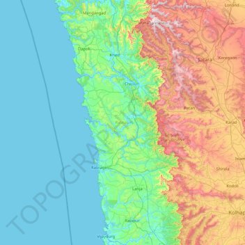
Name: Ratnagiri topographic map, elevation, terrain.
Location: Ratnagiri, Maharashtra, India (16.49151 73.02847 18.06905 73.87468)
Average elevation: 298 m
Minimum elevation: -2 m
Maximum elevation: 1,409 m
Other topographic maps
Click on a map to view its topography, its elevation and its terrain.
Pachwad
India > Maharashtra > Thane > Pachwad
Pachwad, Thane, Maharashtra, 400615, India
Average elevation: 87 m
Vasai-Virar
India > Maharashtra > Vasai-Virar
Vasai-Virar, Thane, Maharashtra, 401209, India
Average elevation: 33 m
Karjat
India > Maharashtra > Karjat
Karjat, Kulāba, Raigad, Maharashtra, 410201, India
Average elevation: 109 m