
Omak topographic map
Interactive map
Click on the map to display elevation.
About this map
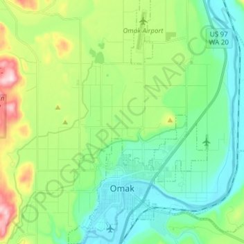
Name: Omak topographic map, elevation, terrain.
Location: Omak, Okanogan County, Washington, 98841, United States (48.39207 -119.55500 48.47666 -119.48419)
Average elevation: 364 m
Minimum elevation: 249 m
Maximum elevation: 658 m
Elevations around the area range from 780 feet (240 m) above sea level at the mouth of the Okanogan River to 6,774 feet (2,065 m) above sea level at the Moses Mountain. The average elevation is 843 feet (257 m) above sea level according to the United States Geological Survey (USGS). The Moses Mountain, with a summit, sits east of the city, while Little Moses Mountain, located 5,963 feet (1,818 m) above sea level, and Omak Mountain, located 5,749 feet (1,752 m) above sea level, are adjacent to the Moses Mountain. West of the city are the North Cascades, anchored by the Cascade Range. Mountain peaks on the western portion of the Omak area range between 6,000 feet (1,800 m) and 8,000 feet (2,400 m). The Coleman Butte mountain summit—1,450 feet (440 m) above sea level—is located directly adjacent to municipal boundaries.
Other topographic maps
Click on a map to view its topography, its elevation and its terrain.
Mud Lake
United States > Washington > Okanogan County
Mud Lake, Okanogan County, Washington, United States
Average elevation: 813 m
Nespelem
United States > Washington > Okanogan County
Nespelem, Okanogan County, Washington, United States
Average elevation: 615 m
Coulee Dam
United States > Washington > Okanogan County
Coulee Dam, Okanogan County, Washington, 99116, United States
Average elevation: 422 m
Havillah
United States > Washington > Okanogan County
Havillah, Okanogan County, Washington, United States
Average elevation: 1,117 m
Conconully
United States > Washington > Okanogan County
Conconully, Okanogan County, Washington, 98819, United States
Average elevation: 832 m
Mary Ann Lake
United States > Washington > Okanogan County
Mary Ann Lake, Okanogan County, Washington, United States
Average elevation: 1,088 m
Wauconda
United States > Washington > Okanogan County
Wauconda, Okanogan County, Washington, United States
Average elevation: 1,183 m
Mazama
United States > Washington > Okanogan County
Mazama, Okanogan County, Washington, 98833, United States
Average elevation: 827 m
Stubblefield Point
United States > Washington > Okanogan County
Stubblefield Point, Okanogan County, Washington, United States
Average elevation: 676 m
Baker Mountain
United States > Washington > Okanogan County
Baker Mountain, Okanogan County, Washington, United States
Average elevation: 902 m
Winthrop
United States > Washington > Okanogan County
Winthrop, Okanogan County, Washington, 98862, United States
Average elevation: 567 m
Point Defiance
United States > Washington > Okanogan County
Point Defiance, Okanogan County, Washington, United States
Average elevation: 1,839 m
Aeneas Mountain
United States > Washington > Okanogan County
Aeneas Mountain, Okanogan County, Washington, United States
Average elevation: 1,255 m
Mount Barney
United States > Washington > Okanogan County
Mount Barney, Okanogan County, Washington, United States
Average elevation: 2,037 m
Silver Star Mountain
United States > Washington > Okanogan County
Silver Star Mountain, Okanogan County, Washington, United States
Average elevation: 2,161 m
Tonasket
United States > Washington > Okanogan County
Tonasket, Okanogan County, Washington, 98855, United States
Average elevation: 342 m
Twisp
United States > Washington > Okanogan County
Twisp, Okanogan County, Washington, 98856, United States
Average elevation: 580 m
Elmer City
United States > Washington > Okanogan County
Elmer City, Okanogan County, Washington, 99124, United States
Average elevation: 431 m
Rock Mountain
United States > Washington > Okanogan County
Rock Mountain, Okanogan County, Washington, United States
Average elevation: 2,154 m
Methow
United States > Washington > Okanogan County > Methow
Methow, Okanogan County, Washington, 98834, United States
Average elevation: 487 m
Mission Peak
United States > Washington > Okanogan County
Mission Peak, Okanogan County, Washington, United States
Average elevation: 1,468 m
Pateros
United States > Washington > Okanogan County
Pateros, Okanogan County, Washington, 98846, United States
Average elevation: 334 m
Molson
United States > Washington > Okanogan County
Molson, Okanogan County, Washington, United States
Average elevation: 1,206 m
Pasayten Wilderness
United States > Washington > Okanogan County
Pasayten Wilderness, Okanogan County, Washington, United States
Average elevation: 1,599 m