
Thank you for supporting this site ❤️
Make a donation
Make a donation
Forest Park topographic map
Click on the map to display elevation.
Thank you for supporting this site ❤️
Make a donation
Make a donation
About this map
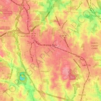
Name: Forest Park topographic map, elevation, terrain.
Location: Forest Park, Clayton County, Georgia, 30297, United States (33.58750 -84.40241 33.64807 -84.30752)
Average elevation: 283 m
Minimum elevation: 215 m
Maximum elevation: 317 m
Thank you for supporting this site ❤️
Make a donation
Make a donation
Other topographic maps
Click on a map to view its topography, its elevation and its terrain.