
Thank you for supporting this site ❤️
Make a donation
Make a donation
Point Pleasant topographic map
Click on the map to display elevation.
Thank you for supporting this site ❤️
Make a donation
Make a donation
About this map
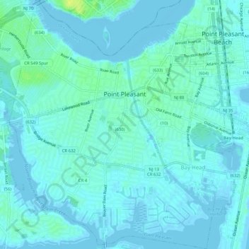
Name: Point Pleasant topographic map, elevation, terrain.
Average elevation: 3 m
Minimum elevation: -4 m
Maximum elevation: 17 m
Thank you for supporting this site ❤️
Make a donation
Make a donation
Other topographic maps
Click on a map to view its topography, its elevation and its terrain.
Thank you for supporting this site ❤️
Make a donation
Make a donation
Thank you for supporting this site ❤️
Make a donation
Make a donation
Thank you for supporting this site ❤️
Make a donation
Make a donation
Story Island Channel
United States > New Jersey > Ocean County > Little Egg Harbor Township
Average elevation: 0 m
Barnegat Beach
United States > New Jersey > Ocean County > Ocean Township > Waretown
Average elevation: 4 m
Thank you for supporting this site ❤️
Make a donation
Make a donation