
Mécheria topographic map
Interactive map
Click on the map to display elevation.
About this map
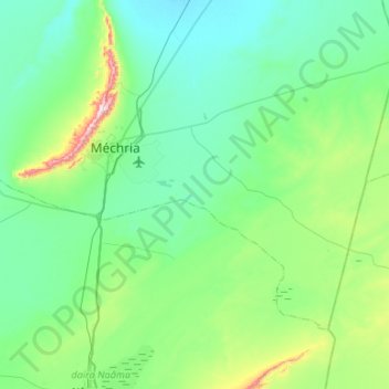
Name: Mécheria topographic map, elevation, terrain.
Location: Mécheria, daïra Mecheria, Naâma, Algérie (33.33528 -0.42021 33.64338 0.11053)
Average elevation: 1,141 m
Minimum elevation: 1,052 m
Maximum elevation: 1,710 m
Other topographic maps
Click on a map to view its topography, its elevation and its terrain.
El Biod
Algérie > Naâma > daïra Mecheria
El Biod, daïra Mecheria, Naâma, Algérie
Average elevation: 1,077 m
Aïn Ben Khellil
Algérie > Naâma > daïra Mecheria > Aïn Ben Khellil
Aïn Ben Khellil, daïra Mecheria, Naâma, Algérie
Average elevation: 1,223 m