
溆浦县 topographic map
Interactive map
Click on the map to display elevation.
About this map
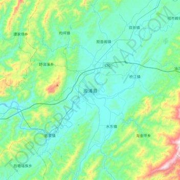
Name: 溆浦县 topographic map, elevation, terrain.
Location: 溆浦县, 怀化市, 湖南省, 中国 (27.75201 110.43021 28.07201 110.75021)
Average elevation: 343 m
Minimum elevation: 127 m
Maximum elevation: 1,293 m
溆浦县处于雪峰山主峰的北向伸延地区,四周山峦重迭,地势东南高、西北低,最高点为南部凉风界海拔1614米,最低点为西部沅水出境地海拔118米。境内最大山峰为雷坡山。
Other topographic maps
Click on a map to view its topography, its elevation and its terrain.