
古丈县 topographic map
Interactive map
Click on the map to display elevation.
About this map
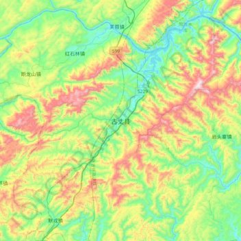
Name: 古丈县 topographic map, elevation, terrain.
Location: 古丈县, 湘西土家族苗族自治州, 湖南省, 中国 (28.46062 109.78603 28.78062 110.10603)
Average elevation: 508 m
Minimum elevation: 185 m
Maximum elevation: 1,118 m
武陵山脉斜贯全境,最高海拔1146米,最低海拔147米;主要河流为酉水。相邻的县级行政区,北接永顺,东临沅陵,南界泸溪和吉首,西部和花垣相连。
Other topographic maps
Click on a map to view its topography, its elevation and its terrain.