
Chaoyang topographic map
Interactive map
Click on the map to display elevation.
About this map
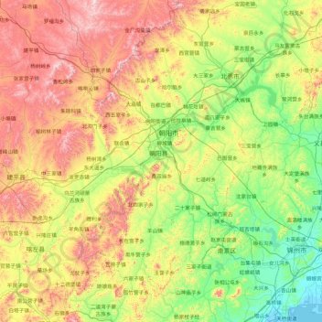
Name: Chaoyang topographic map, elevation, terrain.
Location: Chaoyang, Chaoyang City, Liaoning, PRC (40.81624 119.76078 42.09624 121.04078)
Average elevation: 367 m
Minimum elevation: -1 m
Maximum elevation: 1,158 m
Other topographic maps
Click on a map to view its topography, its elevation and its terrain.
Shenyang City
PRC > Liaoning > Shenyang City
Liaohe Subdistrict, Huanggu District, Shenyang City, Liaoning, PRC
Average elevation: 53 m