Geolocate

桑梓店街道 topographic map

Interactive map

Click on the map to display elevation.

About this map

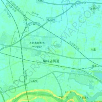
Name: 桑梓店街道 topographic map, elevation, terrain.

Location: 桑梓店街道, 济南新旧动能转换起步区, 天桥区, 济南市, 山东省, 250000, 中国 (36.73651 116.85853 36.84541 116.96175)

Average elevation: 26 m

Minimum elevation: 22 m

Maximum elevation: 41 m

Other topographic maps

Click on a map to view its topography, its elevation and its terrain.

济南新旧动能转换起步区

中国 > 山东省 > 天桥区

济南新旧动能转换起步区, 天桥区, 济南市, 山东省, 250000, 中国

Average elevation: 27 m

制锦市街道

中国 > 山东省 > 天桥区

制锦市街道, 天桥区, 济南市, 山东省, 250000, 中国, 五龙潭

Average elevation: 37 m

大桥街道

中国 > 山东省 > 天桥区

大桥街道, 济南新旧动能转换起步区, 天桥区, 济南市, 山东省, 250000, 中国

Average elevation: 25 m

五龙潭公园

中国 > 山东省 > 天桥区 > 制锦市街道

五龙潭公园, 制锦市小区, 制锦市街道, 天桥区, 济南市, 山东省, 250000, 中国

Average elevation: 36 m

泺口街道

中国 > 山东省 > 天桥区 > 泺口街道

泺口街道, 天桥区, 济南市, 山东省, 250000, 中国

Average elevation: 29 m