
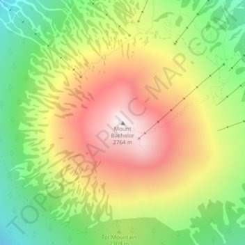
Mount Bachelor topographic map
Interactive map
Click on the map to display elevation.
About this map
Name: Mount Bachelor topographic map, elevation, terrain.
Location: Mount Bachelor, Deschutes County, Oregon, United States (43.97923 -121.68842 43.97933 -121.68832)
Average elevation: 2,327 m
Minimum elevation: 1,928 m
Maximum elevation: 2,756 m
Mount Bachelor lies in the Cascade Range, within Deschutes County, in the U.S. state of Oregon. It is located south of the Three Sisters complex volcano, and reaches an elevation of 9,068 feet (2,764 m). It rises 3,500 feet (1,100 m) above its base, with a proximal relief of 2,674 feet (815 m). The volcano has a volume of 6.0 cubic miles (25 km3). Mount Bachelor stands 3 miles (4.8 km) southeast of the Tumalo Mountain volcano and 18 miles (29 km) to the southwest of the city of Bend, in the Deschutes National Forest.
Other topographic maps
Click on a map to view its topography, its elevation and its terrain.
Bend
United States > Oregon > Deschutes County
Bend, Deschutes County, Oregon, United States
Average elevation: 1,121 m
La Pine
United States > Oregon > Deschutes County
La Pine, Deschutes County, Oregon, 97739, United States
Average elevation: 1,290 m
Redmond
United States > Oregon > Deschutes County
Redmond, Deschutes County, Oregon, 91156, United States
Average elevation: 923 m
Sunriver
United States > Oregon > Deschutes County
Sunriver, Deschutes County, Oregon, 97707, United States
Average elevation: 1,312 m
Anns Butte
United States > Oregon > Deschutes County
Anns Butte, Deschutes County, Oregon, United States
Average elevation: 1,312 m
Sisters
United States > Oregon > Deschutes County
Sisters, Deschutes County, Oregon, United States
Average elevation: 973 m
Archie Briggs Canyon Natural Area
United States > Oregon > Deschutes County > Bend
Archie Briggs Canyon Natural Area, Northwest Falcon Ridge, Bend, Deschutes County, Oregon, 97703, United States
Average elevation: 1,115 m
Three Rivers
United States > Oregon > Deschutes County > Sunriver
Three Rivers, Sunriver, Deschutes County, Oregon, United States
Average elevation: 1,296 m
Three Sisters
United States > Oregon > Deschutes County
Three Sisters, Deschutes County, Oregon, United States
Average elevation: 2,526 m
Lava Butte
United States > Oregon > Deschutes County
Lava Butte, Deschutes County, Oregon, United States
Average elevation: 1,365 m
Smith Rock State Park
United States > Oregon > Deschutes County > Terrebonne
Smith Rock State Park, 9241, Northeast Crooked River Drive, Terrebonne, Deschutes County, Oregon, 97760, United States
Average elevation: 875 m
Terrebonne
United States > Oregon > Deschutes County > Terrebonne
Terrebonne, Deschutes County, Oregon, United States
Average elevation: 855 m
Tumalo Falls
United States > Oregon > Deschutes County
Tumalo Falls, Deschutes County, Oregon, United States
Average elevation: 1,656 m
Deschutes River Woods
United States > Oregon > Deschutes County
Deschutes River Woods, Deschutes County, Oregon, United States
Average elevation: 1,210 m
Vista Butte
United States > Oregon > Deschutes County
Vista Butte, Deschutes County, Oregon, United States
Average elevation: 1,864 m
Crane Prairie Reservoir
United States > Oregon > Deschutes County
Crane Prairie Reservoir, Deschutes County, Oregon, United States
Average elevation: 1,375 m
Brothers
United States > Oregon > Deschutes County
Brothers, Deschutes County, Oregon, United States
Average elevation: 1,410 m
Pilot Butte
United States > Oregon > Deschutes County > Bend
Pilot Butte, Bend, Deschutes County, Oregon, 97701, United States
Average elevation: 1,113 m