
Durkee topographic map
Interactive map
Click on the map to display elevation.
About this map
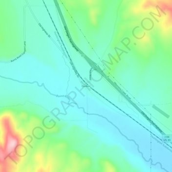
Name: Durkee topographic map, elevation, terrain.
Location: Durkee, Baker County, Oregon, 97905, United States (44.56211 -117.48464 44.60211 -117.44464)
Average elevation: 841 m
Minimum elevation: 781 m
Maximum elevation: 1,027 m
Other topographic maps
Click on a map to view its topography, its elevation and its terrain.
Haines
United States > Oregon > Baker County
Haines, Baker County, Oregon, United States
Average elevation: 1,017 m
Halfway
United States > Oregon > Baker County
Halfway, Baker County, Oregon, 97834, United States
Average elevation: 814 m
Greenhorn
United States > Oregon > Baker County
Greenhorn, Baker County, Oregon, United States
Average elevation: 1,888 m
Rock Creek Butte
United States > Oregon > Baker County
Rock Creek Butte, Baker County, Oregon, United States
Average elevation: 2,349 m
Huntington
United States > Oregon > Baker County
Huntington, Baker County, Oregon, 97907, United States
Average elevation: 715 m
Baker City
United States > Oregon > Baker County
Baker City, Baker County, Oregon, 97814, United States
Average elevation: 1,084 m
Sumpter
United States > Oregon > Baker County
Sumpter, Baker County, Oregon, 97877, United States
Average elevation: 1,393 m