
Cave Junction topographic map
Interactive map
Click on the map to display elevation.
About this map
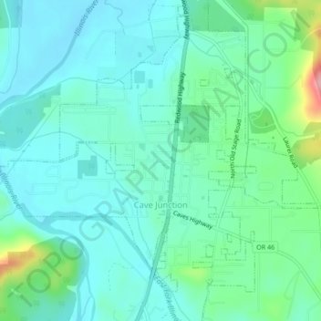
Name: Cave Junction topographic map, elevation, terrain.
Location: Cave Junction, Josephine County, Oregon, United States (42.15189 -123.66918 42.18330 -123.62701)
Average elevation: 410 m
Minimum elevation: 378 m
Maximum elevation: 531 m
Cave Junction is located on U.S. Route 199 at its junction with Oregon Route 46. It is about 30 miles or 48 kilometres southwest of Grants Pass, Oregon and 53 miles or 85 kilometres northeast of Crescent City, California. The city lies in the Illinois Valley, on the northwest slope of the Siskiyou Range, at an elevation of about 480 metres (1,570 ft) above MSL. According to the United States Census Bureau, the city has a total area of 1.82 square miles (4.71 km2), of which, 1.81 square miles (4.69 km2) is land and 0.01 square miles (0.03 km2) is water.
Other topographic maps
Click on a map to view its topography, its elevation and its terrain.
Grants Pass
United States > Oregon > Josephine County
Grants Pass, Josephine County, Oregon, United States
Average elevation: 374 m
Wilderville
United States > Oregon > Josephine County
Wilderville, Josephine County, Oregon, United States
Average elevation: 364 m
O'Brien
United States > Oregon > Josephine County
O'Brien, Josephine County, Oregon, 97534, United States
Average elevation: 454 m
Sunny Valley
United States > Oregon > Josephine County
Sunny Valley, Josephine County, Oregon, 97497, United States
Average elevation: 476 m
Redwood
United States > Oregon > Josephine County
Redwood, Josephine County, Oregon, United States
Average elevation: 300 m
Fruitdale
United States > Oregon > Josephine County > Grants Pass
Fruitdale, Grants Pass, Josephine County, Oregon, 97506, United States
Average elevation: 346 m
Grants Pass
United States > Oregon > Josephine County
Grants Pass, Josephine County, Oregon, United States
Average elevation: 377 m
Williams
United States > Oregon > Josephine County
Williams, Josephine County, Oregon, 97544, United States
Average elevation: 484 m
Merlin
United States > Oregon > Josephine County
Merlin, Josephine County, Oregon, 57526, United States
Average elevation: 308 m
Galice
United States > Oregon > Josephine County > Galice
Galice, Josephine County, Oregon, United States
Average elevation: 402 m
Wolf Creek
United States > Oregon > Josephine County
Wolf Creek, Josephine County, Oregon, 97497, United States
Average elevation: 522 m