
Thank you for supporting this site ❤️
Make a donation
Make a donation
Galice topographic map
Click on the map to display elevation.
Thank you for supporting this site ❤️
Make a donation
Make a donation
About this map
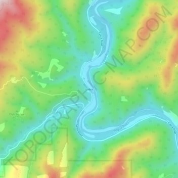
Name: Galice topographic map, elevation, terrain.
Location: Galice, Josephine County, Oregon, United States (42.54918 -123.61614 42.58918 -123.57614)
Average elevation: 402 m
Minimum elevation: 200 m
Maximum elevation: 769 m
Thank you for supporting this site ❤️
Make a donation
Make a donation
Other topographic maps
Click on a map to view its topography, its elevation and its terrain.
Cave Junction
United States > Oregon > Josephine County
Cave Junction is located on U.S. Route 199 at its junction with Oregon Route 46. It is about 30 miles or 48 kilometres southwest of Grants Pass, Oregon, and 53 miles or 85 kilometres northeast of Crescent City, California. The city lies in the Illinois Valley, on the northwest slope of the Siskiyou Range, at…
Average elevation: 411 m
Thank you for supporting this site ❤️
Make a donation
Make a donation