
Oyo State topographic map
Interactive map
Click on the map to display elevation.
About this map
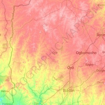
Name: Oyo State topographic map, elevation, terrain.
Location: Oyo State, Nigeria (7.08010 2.67693 9.18831 4.56900)
Average elevation: 271 m
Minimum elevation: 16 m
Maximum elevation: 599 m
Other topographic maps
Click on a map to view its topography, its elevation and its terrain.
Imogwu-Agwa
Nigeria > Rivers > Imogwu-Agwa
Imogwu-Agwa, Ikwerre, Rivers, Nigeria
Average elevation: 22 m
Abuja
Nigeria > Federal Capital Territory > Abuja
Abuja, Municipal Area Council, Federal Capital Territory, 900001, Nigeria
Average elevation: 508 m
Kainji Reservoir
Kainji Reservoir, Gafara, Ngaski, Kebbi, Nigeria
Average elevation: 137 m