
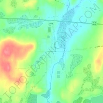
Marenisco topographic map
Interactive map
Click on the map to display elevation.
About this map
Name: Marenisco topographic map, elevation, terrain.
Average elevation: 477 m
Minimum elevation: 449 m
Maximum elevation: 527 m
Other topographic maps
Click on a map to view its topography, its elevation and its terrain.
Wakefield
United States > Michigan > Gogebic County
Wakefield, Gogebic County, Michigan, 49968, United States
Average elevation: 460 m
Ramsay
United States > Michigan > Gogebic County
Ramsay, Bessemer Township, Gogebic County, Michigan, 49959, United States
Average elevation: 467 m
Puritan
United States > Michigan > Gogebic County
Puritan, Bessemer Township, Gogebic County, Michigan, 49911, United States
Average elevation: 463 m
Ironwood
United States > Michigan > Gogebic County
Ironwood, Gogebic County, Michigan, United States
Average elevation: 458 m
Ironwood Township
United States > Michigan > Gogebic County
Ironwood Township, Gogebic County, Michigan, United States
Average elevation: 311 m
Copper Peak
United States > Michigan > Gogebic County
Copper Peak, Ironwood Township, Gogebic County, Michigan, United States
Average elevation: 356 m
Fishhawk Lake
United States > Michigan > Gogebic County
Fishhawk Lake, Watersmeet Township, Gogebic County, Michigan, United States
Average elevation: 517 m
Watersmeet
United States > Michigan > Gogebic County
Watersmeet, Watersmeet Township, Gogebic County, Michigan, 49969, United States
Average elevation: 499 m
Bessemer
United States > Michigan > Gogebic County
Bessemer, Gogebic County, Michigan, 49911, United States
Average elevation: 458 m