
Thank you for supporting this site ❤️
Make a donation
Make a donation
Bessemer topographic map
Click on the map to display elevation.
Thank you for supporting this site ❤️
Make a donation
Make a donation
About this map
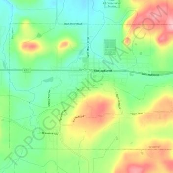
Name: Bessemer topographic map, elevation, terrain.
Location: Bessemer, Gogebic County, Michigan, 49911, United States (46.46298 -90.07857 46.49202 -90.02088)
Average elevation: 458 m
Minimum elevation: 399 m
Maximum elevation: 544 m
Thank you for supporting this site ❤️
Make a donation
Make a donation
Other topographic maps
Click on a map to view its topography, its elevation and its terrain.