
Make a donation
Park Point topographic map
Click on the map to display elevation.
Make a donation
About this map
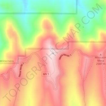
Name: Park Point topographic map, elevation, terrain.
Location: Park Point, Montezuma County, Colorado, United States (37.28034 -108.46154 37.28044 -108.46144)
Average elevation: 2,395 m
Minimum elevation: 2,104 m
Maximum elevation: 2,611 m
Make a donation
Other topographic maps
Click on a map to view its topography, its elevation and its terrain.
Mesa Verde National Park
United States > Colorado > Montezuma County
The early Archaic people living near Mesa Verde utilized the atlatl and harvested a wider variety of plants and animals than the Paleo-Indians had while retaining their primarily nomadic lifestyle. They inhabited the outlying areas of the Mesa Verde region, but also the mountains, mesa tops, and canyons, where…
Average elevation: 2,147 m
Cortez
United States > Colorado > Montezuma County
Cortez has a dry-summer continental climate (Köppen Dsb), though it borders on a semi-arid climate (BSk) due to low precipitation. The city has hot summer days and cold winter nights, the latter a result of its elevation.
Average elevation: 1,865 m
Mancos
United States > Colorado > Montezuma County
According to the United States Census Bureau, Mancos has a total area of 0.6 square miles (1.6 km2), all of it recorded as land. The town is located in the Mancos River valley at an elevation of approximately 7,000 feet (2,100 m). The Mancos River was named by Spanish explorers (Rio de los Mancos - "River of…
Average elevation: 2,166 m
Make a donation
Mancos
United States > Colorado > Montezuma County
According to the United States Census Bureau, Mancos has a total area of 0.6 square miles (1.6 km2), all of it recorded as land. The town is located in the Mancos River valley at an elevation of approximately 7,000 feet (2,100 m). The Mancos River was named by Spanish explorers (Rio de los Mancos - "River of…
Average elevation: 2,158 m
Cortez
United States > Colorado > Montezuma County
Cortez has a dry-summer continental climate (Köppen Dsb), though it borders on a semi-arid climate (BSk) due to low precipitation. The city has hot summer days and cold winter nights, the latter a result of its elevation.
Average elevation: 1,865 m
Make a donation
Mancos
United States > Colorado > Montezuma County
According to the United States Census Bureau, Mancos has a total area of 0.6 square miles (1.6 km2), all of it recorded as land. The town is located in the Mancos River valley at an elevation of approximately 7,000 feet (2,100 m). The Mancos River was named by Spanish explorers (Rio de los Mancos - "River of…
Average elevation: 2,166 m
Mesa Verde National Park
United States > Colorado > Montezuma County
The early Archaic people living near Mesa Verde utilized the atlatl and harvested a wider variety of plants and animals than the Paleo-Indians had while retaining their primarily nomadic lifestyle. They inhabited the outlying areas of the Mesa Verde region, but also the mountains, mesa tops, and canyons, where…
Average elevation: 2,147 m
Cortez
United States > Colorado > Montezuma County
Cortez has a dry-summer continental climate (Köppen Dsb), though it borders on a semi-arid climate (BSk) due to low precipitation. The city has hot summer days and cold winter nights, the latter a result of its elevation.
Average elevation: 1,865 m
Make a donation