
Mesa Verde National Park topographic map
Interactive map
Click on the map to display elevation.
About this map
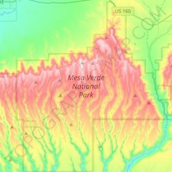
Name: Mesa Verde National Park topographic map, elevation, terrain.
Average elevation: 2,147 m
Minimum elevation: 1,808 m
Maximum elevation: 2,611 m
The early Archaic people living near Mesa Verde utilized the atlatl and harvested a wider variety of plants and animals than the Paleo-Indians had while retaining their primarily nomadic lifestyle. They inhabited the outlying areas of the Mesa Verde region, but also the mountains, mesa tops, and canyons, where they created rock shelters and rock art, and left evidence of animal processing and chert knapping. Environmental stability during the period drove population expansion and migration. Major warming and drying from 5000 to 2500 might have led middle Archaic people to seek the cooler climate of Mesa Verde, whose higher elevation brought increased snowpack that, when coupled with spring rains, provided relatively plentiful amounts of water.
Other topographic maps
Click on a map to view its topography, its elevation and its terrain.
Millwood
United States > Colorado > Montezuma County
Millwood, Montezuma County, Colorado, United States
Average elevation: 2,320 m
Cortez
United States > Colorado > Montezuma County
Cortez, Montezuma County, Colorado, 81321, United States
Average elevation: 1,865 m
Mancos
United States > Colorado > Montezuma County
Mancos, Montezuma County, Colorado, United States
Average elevation: 2,158 m
Chimney Rock
United States > Colorado > Montezuma County
Chimney Rock, Montezuma County, Colorado, United States
Average elevation: 1,640 m
Menefee Peak
United States > Colorado > Montezuma County
Menefee Peak, Montezuma County, Colorado, United States
Average elevation: 2,497 m
Mancos
United States > Colorado > Montezuma County > Mancos
Mancos, Montezuma County, Colorado, 81328-9151, United States
Average elevation: 2,207 m
Cortez
United States > Colorado > Montezuma County > Cortez
Cortez, Montezuma County, Colorado, 81321-3299, United States
Average elevation: 1,869 m
Towaoc
United States > Colorado > Montezuma County > Towaoc
Towaoc, Montezuma County, Colorado, United States
Average elevation: 1,809 m
Hesperus Mountain
United States > Colorado > Montezuma County
Hesperus Mountain, Montezuma County, Colorado, United States
Average elevation: 3,582 m