
玛旁雍错 topographic map
Interactive map
Click on the map to display elevation.
About this map
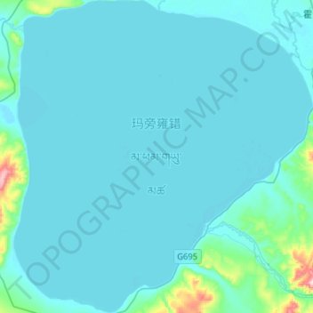
Name: 玛旁雍错 topographic map, elevation, terrain.
Location: 玛旁雍错, 普兰县, 阿里地区, 西藏自治区, 中国 (30.56200 81.36520 30.78423 81.61267)
Average elevation: 4,604 m
Minimum elevation: 4,582 m
Maximum elevation: 4,936 m
瑪旁雍錯(藏文:མ་ཕམ་གཡུ་མཚོ་,威利转写:Ma-pham g.yu-mtsho,意為“不敗之碧湖”),玛那萨罗瓦(Mānasa Sarovara, मानस सरोवर,義爲“意念=末那湖泊”)等,是世界上平均海拔最高的淡水湖(4,556米),位于中国西藏普兰县境内,属国家级自然保护区,也是自治区级风景名胜区的组成部分,已列入《世界遗产预备名单》。
Other topographic maps
Click on a map to view its topography, its elevation and its terrain.