
Providence County topographic map
Interactive map
Click on the map to display elevation.
About this map
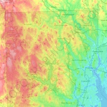
Name: Providence County topographic map, elevation, terrain.
Location: Providence County, Rhode Island, United States (41.72456 -71.79920 42.01894 -71.31774)
Average elevation: 108 m
Minimum elevation: -7 m
Maximum elevation: 272 m
Other topographic maps
Click on a map to view its topography, its elevation and its terrain.
Anthony
United States > Rhode Island > Kent County > Coventry
Anthony, Coventry, Kent County, Rhode Island, 02816, United States
Average elevation: 71 m
Narragansett
United States > Rhode Island > South County
Narragansett, South County, Rhode Island, 02882, United States
Average elevation: 12 m
Hope Valley
United States > Rhode Island > South County > Hopkinton
Hope Valley, Hopkinton, South County, Rhode Island, 02832, United States
Average elevation: 54 m
North Kingstown
United States > Rhode Island > South County
North Kingstown, South County, Rhode Island, United States
Average elevation: 35 m
South County
South County, Rhode Island, United States
Average elevation: 30 m
Barrington
United States > Rhode Island > Bristol County
Barrington, Bristol County, Rhode Island, 02806, United States
Average elevation: 4 m
Smithfield
United States > Rhode Island > Providence County
Smithfield, Providence County, Rhode Island, United States
Average elevation: 107 m
East Greenwich
United States > Rhode Island > Kent County
East Greenwich, Kent County, Rhode Island, 02818, United States
Average elevation: 21 m
Ashaway
United States > Rhode Island > South County > Hopkinton > Ashaway
Ashaway, Hopkinton, South County, Rhode Island, 02804, United States
Average elevation: 31 m
Scituate
United States > Rhode Island > Providence County
Scituate, Providence County, Rhode Island, United States
Average elevation: 124 m
Charlestown
United States > Rhode Island > South County
Charlestown, South County, Rhode Island, 02813, United States
Average elevation: 22 m
Westerly
United States > Rhode Island > Washington County
Westerly, Washington County, Rhode Island, 02808, United States
Average elevation: 19 m
Portsmouth
United States > Rhode Island > Newport County
Portsmouth, Newport County, Rhode Island, United States
Average elevation: 19 m
Fort Wetherill
United States > Rhode Island > Newport County > Jamestown
Fort Wetherill, Highland Drive, Jamestown, Newport County, Rhode Island, 02835, United States
Average elevation: 4 m
Ell Pond
United States > Rhode Island > South County > Hopkinton
Ell Pond, Hopkinton, South County, Rhode Island, United States
Average elevation: 105 m
East Providence
United States > Rhode Island > Providence County
East Providence, Providence County, Rhode Island, United States
Average elevation: 12 m
Weekapaug
United States > Rhode Island > South County > Westerly
Weekapaug, Westerly, South County, Rhode Island, United States
Average elevation: 8 m
Long Pond
United States > Rhode Island > South County > New Shoreham
Long Pond, New Shoreham, South County, Rhode Island, United States
Average elevation: 19 m
Coventry
United States > Rhode Island > Kent County
Coventry, Kent County, Rhode Island, United States
Average elevation: 126 m
Aquidneck Island
United States > Rhode Island > Newport County > Portsmouth
Aquidneck Island, Portsmouth, Newport County, Rhode Island, United States
Average elevation: 13 m
Johnston
United States > Rhode Island > Providence County
Johnston, Providence County, Rhode Island, 02919, United States
Average elevation: 97 m
Prudence Island
United States > Rhode Island > Portsmouth
Prudence Island, Portsmouth, Newport County, Rhode Island, United States
Average elevation: 6 m
Ashton
United States > Rhode Island > Providence County > Cumberland
Ashton, Cumberland, Providence County, Rhode Island, 02864, United States
Average elevation: 60 m
Narragansett Bay
Narragansett Bay, Newport County, Rhode Island, 02783, United States
Average elevation: 4 m
Newport
United States > Rhode Island > Newport County
Newport, Newport County, Rhode Island, 02840, United States
Average elevation: 8 m
Pocasset Hill
United States > Rhode Island > Newport County > Tiverton
Pocasset Hill, Tiverton, Newport County, Rhode Island, 02878, United States
Average elevation: 51 m
Apponaug
United States > Rhode Island > Kent County
Apponaug, Kent County, Rhode Island, 02886, United States
Average elevation: 23 m
Bristol County
Bristol County, Rhode Island, United States
Average elevation: 6 m
Crompton
United States > Rhode Island > Kent County > West Warwick
Crompton, West Warwick, Kent County, Rhode Island, 02893, United States
Average elevation: 63 m
Pawtucket
United States > Rhode Island > Providence County
Pawtucket, Providence County, Rhode Island, United States
Average elevation: 24 m
Durfee Hill
United States > Rhode Island > Providence County > Glocester
Durfee Hill, Glocester, Providence County, Rhode Island, United States
Average elevation: 211 m
Hope Valley
United States > Rhode Island > South County > Hopkinton > Hope Valley
Hope Valley, Hopkinton, South County, Rhode Island, 02832, United States
Average elevation: 55 m
Wakefield
United States > Rhode Island > South County > South Kingstown > Wakefield
Wakefield, South Kingstown, South County, Rhode Island, 02879, United States
Average elevation: 23 m
Jamestown
United States > Rhode Island > Newport County
Jamestown, Newport County, Rhode Island, 02835, United States
Average elevation: 8 m
Conservation Land (Trails)
United States > Rhode Island > Providence County > Cumberland
Conservation Land (Trails), Lippitt Estate, Cumberland, Providence County, Rhode Island, United States
Average elevation: 73 m
Seekonk River
United States > Rhode Island > Providence County
Seekonk River, Pawtucket, Providence County, Rhode Island, 02860, United States
Average elevation: 21 m
Providence
United States > Rhode Island > Providence County
Providence, Providence County, Rhode Island, United States
Average elevation: 19 m
Middletown
United States > Rhode Island > Newport County
Middletown, Newport County, Rhode Island, 02842, United States
Average elevation: 19 m
Olneyville
United States > Rhode Island > Providence County > Providence > Olneyville
Olneyville, Providence, Providence County, Rhode Island, 02909, United States
Average elevation: 24 m
West Greenwich
United States > Rhode Island > Kent County > West Greenwich
West Greenwich, Kent County, Rhode Island, 02817, United States
Average elevation: 111 m
Kent County
Kent County, Rhode Island, United States
Average elevation: 92 m
Foster
United States > Rhode Island > Providence County
Foster, Providence County, Rhode Island, 02825, United States
Average elevation: 171 m
Exeter
United States > Rhode Island > South County > Exeter
Exeter, South County, Rhode Island, 02822, United States
Average elevation: 56 m
Saunderstown
United States > Rhode Island > South County > North Kingstown > Saunderstown
Saunderstown, North Kingstown, South County, Rhode Island, 02874, United States
Average elevation: 14 m
Pascoag
United States > Rhode Island > Providence County > Burrillville > Pascoag
Pascoag, Burrillville, Providence County, Rhode Island, 02859, United States
Average elevation: 141 m
New Shoreham
United States > Rhode Island > South County
New Shoreham, South County, Rhode Island, 02807, United States
Average elevation: 5 m
Glocester
United States > Rhode Island > Providence County
Glocester, Providence County, Rhode Island, United States
Average elevation: 166 m
Wickford
United States > Rhode Island > South County > North Kingstown > Wickford
Wickford, North Kingstown, South County, Rhode Island, 02852, United States
Average elevation: 12 m
Kingston
United States > Rhode Island > South County > South Kingstown > Kingston
Kingston, South Kingstown, South County, Rhode Island, 02881, United States
Average elevation: 47 m
Block Island
United States > Rhode Island > South County > New Shoreham
Block Island, New Shoreham, South County, Rhode Island, 02807, United States
Average elevation: 5 m