
East Greenwich topographic map
Interactive map
Click on the map to display elevation.
About this map
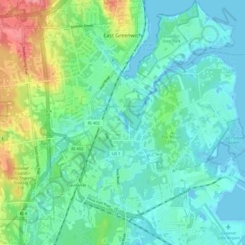
Name: East Greenwich topographic map, elevation, terrain.
Average elevation: 21 m
Minimum elevation: -6 m
Maximum elevation: 86 m
Other topographic maps
Click on a map to view its topography, its elevation and its terrain.
Anthony
United States > Rhode Island > Kent County > Coventry
Anthony, Coventry, Kent County, Rhode Island, 02816, United States
Average elevation: 71 m
Coventry
United States > Rhode Island > Kent County
Coventry, Kent County, Rhode Island, United States
Average elevation: 126 m
Apponaug
United States > Rhode Island > Kent County
Apponaug, Kent County, Rhode Island, 02886, United States
Average elevation: 23 m
Crompton
United States > Rhode Island > Kent County > West Warwick
Crompton, West Warwick, Kent County, Rhode Island, 02893, United States
Average elevation: 63 m
West Greenwich
United States > Rhode Island > Kent County > West Greenwich
West Greenwich, Kent County, Rhode Island, 02817, United States
Average elevation: 111 m
Warwick
United States > Rhode Island > Kent County
Warwick, Kent County, Rhode Island, United States
Average elevation: 34 m