
苍溪县 topographic map
Interactive map
Click on the map to display elevation.
About this map
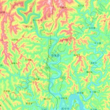
Name: 苍溪县 topographic map, elevation, terrain.
Location: 苍溪县, 广元市, 四川省, 中国 (31.57455 105.77485 31.89455 106.09485)
Average elevation: 514 m
Minimum elevation: 339 m
Maximum elevation: 901 m
苍溪县属低山区,境内地势东北高,西南低,以九龙山主峰为最高,海拔1369.2米,嘉陵江出境处涧溪口海拔352米最低。整个地貌由低山和深丘及河谷平坝构成。土壤酸碱度为5.8-8.2。
Other topographic maps
Click on a map to view its topography, its elevation and its terrain.