
Make a donation
Buzet topographic map
Click on the map to display elevation.
Make a donation
About this map
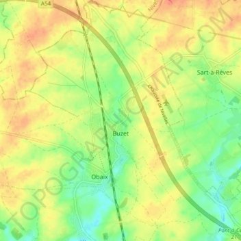
Name: Buzet topographic map, elevation, terrain.
Average elevation: 148 m
Minimum elevation: 124 m
Maximum elevation: 167 m
Make a donation
Other topographic maps
Click on a map to view its topography, its elevation and its terrain.
Make a donation
Make a donation
Make a donation
Make a donation
Montigny-le-Tilleul
Belgique > Hainaut > Charleroi
La commune est traversée par la Sambre et bordée à l'est par son affluent l'Eau d'Heure. Son altitude varie de 100 mètres au niveau de la Sambre à 215 mètres dans le quartier Vésale. Le relief est parfois accidenté avec des affleurements de rochers surtout en bord de Sambre qui a creusé une profonde…
Average elevation: 157 m
Make a donation
Charleroi
Belgique > Hainaut > Charleroi > Charleroi
L'altitude va de 100 mètres (vallée de la Sambre et du Piéton) pour culminer à plus de 220 mètres au Bois du Prince à Marcinelle. Le niveau est de 132 mètres sur la place Charles II. L'altitude des terrils dépasse souvent 200 mètres, le terril Saint-Charles du bois du Cazier atteint 241 mètres.
Average elevation: 170 m
Make a donation
Make a donation
Make a donation
Make a donation
Make a donation
Make a donation
Make a donation