
Thank you for supporting this site ❤️
Make a donation
Make a donation
Hunjiang District topographic map
Click on the map to display elevation.
Thank you for supporting this site ❤️
Make a donation
Make a donation
About this map
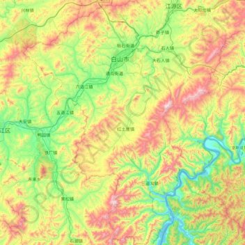
Name: Hunjiang District topographic map, elevation, terrain.
Location: Hunjiang District, Baishan City, Jilin, 134300, China (41.49822 126.11373 42.07301 126.68680)
Average elevation: 708 m
Minimum elevation: 284 m
Maximum elevation: 1,504 m
Thank you for supporting this site ❤️
Make a donation
Make a donation
Other topographic maps
Click on a map to view its topography, its elevation and its terrain.