
On Li Sai Tsuen topographic map
Interactive map
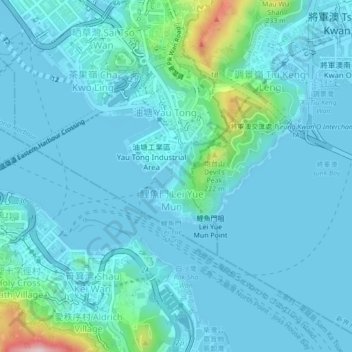
Click on the map to display elevation.
About this map
Name: On Li Sai Tsuen topographic map, elevation, terrain.
Location: On Li Sai Tsuen, Kwun Tong District, Hong Kong, SIL 739, PRC (22.27132 114.21925 22.31132 114.25925)
Average elevation: 39 m
Minimum elevation: -2 m
Maximum elevation: 340 m
Other topographic maps
Click on a map to view its topography, its elevation and its terrain.
Kwun Tong Tsai Wan
Kwun Tong Tsai Wan, Ko Fai Road, Yau Tong, On Li Sai Tsuen, Kwun Tong District, Hong Kong, SIL 739, PRC
Average elevation: 43 m