
Make a donation
Fisher Peak topographic map
Click on the map to display elevation.
Make a donation
About this map
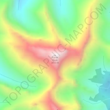
Name: Fisher Peak topographic map, elevation, terrain.
Average elevation: 2,531 m
Minimum elevation: 2,166 m
Maximum elevation: 3,034 m
Make a donation
Other topographic maps
Click on a map to view its topography, its elevation and its terrain.
Calgary
Calgary, Alberta, is uniquely positioned in the transition zone between the rolling Canadian Prairies to the east and the rugged foothills of the Canadian Rockies to the west, creating a landscape of undulating hills, plateau-like uplands, and deep river valleys. The Bow and Elbow Rivers carve prominent bluffs…
Average elevation: 1,106 m
Edmonton
Edmonton is on the North Saskatchewan River, at an elevation of 671 m (2,201 ft). It is North America's northernmost city with a metropolitan population over one million. It is at the same latitude as Hamburg (Germany); Dublin (Ireland); Manchester (United Kingdom); and Magnitogorsk (Russia). It is south of…
Average elevation: 690 m
Fort McMurray
Canada > Alberta > Wood Buffalo
The community lies at a lower elevation than most other parts of Alberta, so under the right conditions it can be a "hot spot" for Alberta.
Average elevation: 345 m
Make a donation
Nose Hill Park
Names currently associated with topographical features in and near Nose Hill Park reflect the impact of the European newcomers and European trade goods on the Peigan. For example, Spy Hill, the westward extension of Nose Hill, derived its present name from the aboriginal practice of communicating with distant…
Average elevation: 1,174 m
Make a donation
Make a donation
Make a donation
Grande Prairie
Grande Prairie is located just north of the 55th parallel north, and is 465 km (289 mi) northwest of Edmonton, lying at an elevation of 669 metres (2,195 ft) above sea level. The city is surrounded by farmland to the north, east, and west. To the south lies a vast boreal forest with aspen, tamarack, lodgepole…
Average elevation: 665 m
Make a donation
Brooks
Canada > Alberta > City of Brooks
Brooks is a city in southeast Alberta, Canada in the County of Newell. It is on Highway 1 (Trans-Canada Highway) and the Canadian Pacific Kansas City railway, approximately 186 km (116 mi) southeast of Calgary, and 110 km (68 mi) northwest of Medicine Hat. The city has an elevation of 760 m (2,490 ft).
Average elevation: 758 m
Make a donation
Whitecourt
Whitecourt is a town in Northern Alberta, Canada that is surrounded by Woodlands County. It is approximately 177 km (110 mi) northwest of Edmonton and 279 km (173 mi) southeast of Grande Prairie at the junction of Highway 43 and Highway 32. It has an elevation of 690 m (2,260 ft).
Average elevation: 717 m
Waterton Lakes National Park
Canada > Alberta > Improvement District No. 04
Operated by Parks Canada, Waterton is open all year, but the main tourist season is during July and August. The only commercial facilities available within the park are located at the Waterton Park townsite. This park ranges in elevation from 1,290 metres (4,232 ft) at the townsite to 2,910 m (9,547 ft) at…
Average elevation: 1,778 m
Make a donation
Make a donation
Make a donation
Make a donation
West Bragg Creek Provincial Recreation Area
Canada > Alberta > Kananaskis Improvement District
Average elevation: 1,467 m
Make a donation
Make a donation
Lake Claire
Canada > Alberta > Improvement District No. 24
The lake has a total area of 1,436 km2 (554 sq mi), with 21 km2 (8.1 sq mi) island area, and lies at an elevation of 213 m (699 ft). It is the largest lake located entirely within Albertan boundaries. Lake Athabasca, which straddles the border with Saskatchewan, is larger.
Average elevation: 214 m
Make a donation
Make a donation
Make a donation
Make a donation
Edmonton
Edmonton is on the North Saskatchewan River, at an elevation of 671 metres (2,201 ft). It is North America's northernmost city with a population over one million. It is south of Alberta's geographic centre, which is near the Hamlet of Fort Assiniboine. The terrain in and around Edmonton is generally flat to…
Average elevation: 690 m
Make a donation
Make a donation
Make a donation
Fort McKay
Canada > Alberta > Wood Buffalo
Fort McKay (/məˈkaɪ/ mə-KY) or Fort MacKay is a community in northeast Alberta, Canada, located at the confluence of the Athabasca and MacKay rivers. It is approximately 54 km (34 mi) north of Fort McMurray via Highway 63 and Fort McKay Road. The community has an elevation of 260 m (850 ft).
Average elevation: 259 m
Make a donation
Make a donation
Make a donation
Carbondale River
Canada > Alberta > Municipal District of Pincher Creek No. 9
Average elevation: 1,565 m
Make a donation
Make a donation
Make a donation