
Make a donation
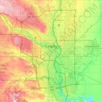
Calgary topographic map
Click on the map to display elevation.
Make a donation
Calgary
Calgary, Alberta, is uniquely positioned in the transition zone between the rolling Canadian Prairies to the east and the rugged foothills of the Canadian Rockies to the west, creating a landscape of undulating hills, plateau-like uplands, and deep river valleys. The Bow and Elbow Rivers carve prominent bluffs and floodplains, adding dramatic relief to the surrounding high plains. Elevation varies widely, from roughly 975 m (3,200 ft) in the eastern river valleys to over 1,290 m (4,232 ft) at western peaks and natural high points like Nose Hill Park. This significant vertical variation, combined with steep escarpments and rolling uplands, gives Calgary a terrain distinctly more complex than the flatter prairie regions, shaping both its visual character and its mountain-influenced climate.
Make a donation
About this map
Name: Calgary topographic map, elevation, terrain.
Location: Calgary, Alberta, Canada (50.84253 -114.31576 51.21250 -113.86000)
Average elevation: 1,104 m
Minimum elevation: 957 m
Maximum elevation: 1,349 m
Make a donation
Other topographic maps
Click on a map to view its topography, its elevation and its terrain.
Canmore
Canada > Alberta > Division No. 15
Elevation Place opened in April 2013 as Canmore's new recreation facility. Construction of the facility began in 2012 to go alongside the Canmore Recreation Centre (the community's old facility). The facility offers an 8-lane 25m lap pool, a world class climbing wall developed by Walltopia, two cardio rooms, a…
Average elevation: 1,565 m