
Bartın topographic map
Interactive map
Click on the map to display elevation.
About this map
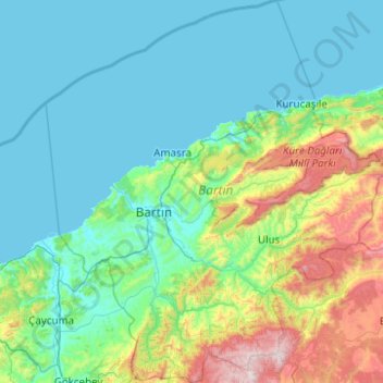
Name: Bartın topographic map, elevation, terrain.
Location: Bartın, Black Sea Region, Türkiye (41.30294 32.05852 42.04300 32.93898)
Average elevation: 295 m
Minimum elevation: 0 m
Maximum elevation: 1,751 m
Other topographic maps
Click on a map to view its topography, its elevation and its terrain.
Bektaş Yaylası
Türkiye > Dereli > Bektaş Yaylası
Bektaş Yaylası, Dereli, Giresun, Black Sea Region, Türkiye
Average elevation: 1,974 m
Kirazdere Barajı
Kirazdere Barajı, Yuvacık Yakacık Mahallesi, Başiskele, Kocaeli, Marmara Region, Türkiye
Average elevation: 241 m