
Sierra County topographic map
Interactive map
Click on the map to display elevation.
Sierra County
Prior to the California Gold Rush, the area was home to both the Maidu and the Washoe peoples. They generally summered in the higher elevations to hunt and fish, and returned to lower elevations for the winter months. After the discovery of gold in the Sierra foothills sparked the California Gold Rush, more than 16,000 miners settled in Sierra County between 1848 and 1860. Most mining settlements in the county sprung up along the North and Middle Forks of the Yuba River, both of which had rich deposits of gold. While some of the mining boom towns faded away once gold fever died down, other settlements such as Downieville and Sierra City have remained.
About this map
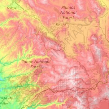
Name: Sierra County topographic map, elevation, terrain.
Location: Sierra County, California, United States (39.39131 -121.05816 39.77689 -120.00115)
Average elevation: 1,690 m
Minimum elevation: 539 m
Maximum elevation: 2,762 m
Other topographic maps
Click on a map to view its topography, its elevation and its terrain.
Cajon Pass
United States > California > San Bernardino County
Cajon Pass (/kəˈhoʊn/; Spanish: Puerto del Cajón or Paso del Cajón) is a mountain pass between the San Bernardino Mountains to the east and the San Gabriel Mountains to the west in Southern California. Created by the movements of the San Andreas Fault, it has an elevation of 3,777 ft (1,151 m). Located in…
Average elevation: 1,169 m
Bowles
United States > California > Fresno County
Bowles is a census-designated place (CDP) in Fresno County, California, United States. The population was 166 at the 2010 census, down from 182 at the 2000 census. Bowles is located 11 miles (18 km) south of downtown Fresno, at an elevation of 279 feet (85 m).
Average elevation: 86 m
Brentwood
United States > California > Contra Costa County > Brentwood > Brentwood
Average elevation: 27 m