
Make a donation
Burdur topographic map
Click on the map to display elevation.
Make a donation
Burdur
The history of the urban development of Burdur is generally held to begin with the Turkish settlement after the Seljuq victory at the Battle of Manzikert in 1071. In the late 11th century, the Kınalı tribe of the Oghuz Turks captured the Burdur area and settled there. Turks became the majority of the population of the area after 1211, establishing a number of villages in addition to expanding the town. The first Turkish settlement was in an area known as Hamam Bendi that had a lower elevation than today's city but was farther to the lake than the ancient town of Limnombria. These residents used the site of today's Grand Mosque of Burdur as an open marketplace, known as Alanpazarı. Realising the high incidence of malaria in the area they had settled, these residents then moved uphill, away from the lake. These first residents had not submitted to any state, but Kilij Arslan II, the Seljuq Sultan of Rum, captured the area in 1177 and imposed his sovereignty over the local tribes. The town remained under the undisputed sovereignty of the Sultanate of Rum between 1206 and 1260, when it was captured by the Mongol Empire. Developing commerce in the port of Antalya increased the significance of Burdur as a centre of commerce. Tragacanth obtained from the mountains of Psidia, wine from Kütahya, wax, wood and tar from many parts of Anatolia passed through Burdur, in exchange of which Egyptian spices, cotton and sugar was traded.
Make a donation
About this map
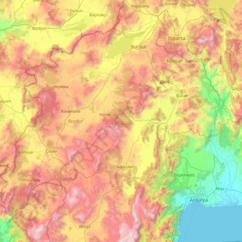
Name: Burdur topographic map, elevation, terrain.
Location: Burdur, Mediterranean Region, Turkey (36.79817 29.32559 37.84616 30.98797)
Average elevation: 1,068 m
Minimum elevation: 0 m
Maximum elevation: 2,797 m
Make a donation
Other topographic maps
Click on a map to view its topography, its elevation and its terrain.
Make a donation
Make a donation
Make a donation
Gaziantep
The plan introduced several important changes to the city's transportation network. One of the most important was the addition of a rail line to connect Gaziantep to the national rail system. Up to now, Turkish railway construction had ignored Gaziantep (partly because of its mountainous surroundings); a…
Average elevation: 880 m
Make a donation
Make a donation
Make a donation
Make a donation
Make a donation
Make a donation
Make a donation
Make a donation
Make a donation
Make a donation
Make a donation
Make a donation
Denizli
Turkey > Denizli > Merkezefendi
Denizli is an industrial city in the southwestern part of Turkey and the eastern end of the alluvial valley formed by the river Büyük Menderes, where the plain reaches an elevation of about three hundred and fifty metres (1,148 ft). Denizli is located in the country's Aegean Region.
Average elevation: 758 m
Make a donation
Make a donation
Make a donation
Mount Ararat
Mount Ararat (/ˈærəræt/ ARR-ə-rat; Turkish: Ağrı Dağı; Armenian: Մասիս, romanized: Masis, and Արարատ, Ararat; Kurdish: Çiyayê Agirî) is a snow-capped and dormant compound volcano in the extreme east of Turkey. It consists of two major volcanic cones: Greater Ararat and Little Ararat.…
Average elevation: 4,582 m
Trabzon
Trabzon has a climate typical of the Black Sea region with plentiful precipitation. Under the Köppen climate classification, it has a humid subtropical climate (Köppen: Cfa) Summers are warm and humid, and the average maximum temperature is around 26.7 °C (80 °F) in August. Winters are cool and damp, and…
Average elevation: 241 m
Make a donation
Make a donation
Karabük
Karabük is a town and the capital district of Karabük Province in the Black Sea region of Turkey. According to the 2009 census, population of the city is 108 167. The district covers an area of 760 km2 (293 sq mi), and the town lies at an elevation of 354 m (1,161 ft).
Average elevation: 864 m
Make a donation
Make a donation
Make a donation
Make a donation
Make a donation