
Xingtai topographic map
Interactive map
Click on the map to display elevation.
About this map
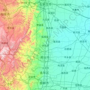
Name: Xingtai topographic map, elevation, terrain.
Location: Xingtai, Hebei, 054000, China (36.75353 113.75171 37.81271 115.84765)
Average elevation: 356 m
Minimum elevation: 20 m
Maximum elevation: 2,076 m
Other topographic maps
Click on a map to view its topography, its elevation and its terrain.
Caofeidian District
Caofeidian District, Tangshan, Hebei, 063210, China
Average elevation: 1 m
Chongli District
China > Hebei > Zhangjiakou
Chongli District, Zhangjiakou, Hebei, 076300, China
Average elevation: 1,448 m
Shuangta Subdistrict
China > Hebei > Zhuozhou City
Shuangta Subdistrict, Zhuozhou City, Baoding City, Hebei, China
Average elevation: 34 m