
Make a donation
Batman topographic map
Click on the map to display elevation.
Make a donation
Batman
The province occupies an area of 4,477 km2 (1,729 sq mi). It lies in a mountainous area with the average elevation of 550 meters which contains several thousands of caves. The tallest mountains are Sason Dağları (2500 m), Meleto (2967 m), Kuşaklı Dağı (1947 m), Avcı Dağı (2121 m), Meydanok Tepesi (2042 m), Kortepe (2082 m) and Raman Dağı (1288 m). Several rivers (Turkish: Çay or Nehir) flow through the province, including Tigris, Batman, Sason and Garzan. The 115 km (71 mi) long Batman River flowing approximately from north to south forms a natural border between the Batman Province and Diyarbakır Province lying to the west. The historic Malabadi Bridge (built in 1146–1147) crosses the river near the town of Silvan. The Tigris flows from west to east, merges with the Batman River and exits the province. The Garzan River flowing from north to south enters the Tigris and separates Batman from the Siirt Province lying to the east. The province is also of interest from an archaeological point of view. Sights include the Imam Abdullah Dervish monastery, the bridge of Camiü‘r Rızk and Hasankeyf.
Make a donation
About this map
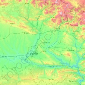
Name: Batman topographic map, elevation, terrain.
Location: Batman, Southeastern Anatolia Region, Turkey (37.49516 40.98644 38.54212 41.82192)
Average elevation: 941 m
Minimum elevation: 407 m
Maximum elevation: 2,929 m
Make a donation
Other topographic maps
Click on a map to view its topography, its elevation and its terrain.
Make a donation
Make a donation
Make a donation
Gaziantep
The plan introduced several important changes to the city's transportation network. One of the most important was the addition of a rail line to connect Gaziantep to the national rail system. Up to now, Turkish railway construction had ignored Gaziantep (partly because of its mountainous surroundings); a…
Average elevation: 880 m
Make a donation
Make a donation
Make a donation
Make a donation
Make a donation
Make a donation
Make a donation
Make a donation
Make a donation
Make a donation
Make a donation
Mount Erciyes
The climate of the region is influenced by topography, with the Taurus and Kaçkar Mountains blocking the entry of moisture into Anatolia. Summers are dry and hot and winters wet and cold; in Kayseri, summer temperatures are about 19 °C (66 °F) and winter temperature about 0 °C (32 °F). Precipitation at…
Average elevation: 3,329 m
Make a donation
Make a donation
Denizli
Turkey > Denizli > Merkezefendi
Denizli is an industrial city in the southwestern part of Turkey and the eastern end of the alluvial valley formed by the river Büyük Menderes, where the plain reaches an elevation of about three hundred and fifty metres (1,148 ft). Denizli is located in the country's Aegean Region.
Average elevation: 758 m
Make a donation
Make a donation
Mount Ararat
Mount Ararat (/ˈærəræt/ ARR-ə-rat; Turkish: Ağrı Dağı; Armenian: Մասիս, romanized: Masis, and Արարատ, Ararat; Kurdish: Çiyayê Agirî) is a snow-capped and dormant compound volcano in the extreme east of Turkey. It consists of two major volcanic cones: Greater Ararat and Little Ararat.…
Average elevation: 4,582 m
Trabzon
Trabzon has a climate typical of the Black Sea region with plentiful precipitation. Under the Köppen climate classification, it has a humid subtropical climate (Köppen: Cfa) Summers are warm and humid, and the average maximum temperature is around 26.7 °C (80 °F) in August. Winters are cool and damp, and…
Average elevation: 241 m
Make a donation
Make a donation
Karabük
Karabük is a town and the capital district of Karabük Province in the Black Sea region of Turkey. According to the 2009 census, population of the city is 108 167. The district covers an area of 760 km2 (293 sq mi), and the town lies at an elevation of 354 m (1,161 ft).
Average elevation: 864 m
Make a donation
Make a donation
Make a donation
Make a donation
Make a donation