
Benton County topographic map
Interactive map
Click on the map to display elevation.
About this map
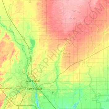
Name: Benton County topographic map, elevation, terrain.
Location: Benton County, Minnesota, USA (45.55911 -94.35320 45.82417 -93.75867)
Average elevation: 340 m
Minimum elevation: 289 m
Maximum elevation: 407 m
Other topographic maps
Click on a map to view its topography, its elevation and its terrain.
Alexandria
USA > Minnesota > Alexandria
Alexandria, Douglas County, Minnesota, 56308, USA
Average elevation: 426 m
Lake of the Woods County
Lake of the Woods County, Minnesota, USA
Average elevation: 343 m
Prospect Park - East River Road
USA > Minnesota > Minneapolis
Prospect Park - East River Road, Minneapolis, Hennepin County, Minnesota, USA
Average elevation: 260 m