
Northern Rockies topographic map
Interactive map
Click on the map to display elevation.
About this map
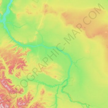
Name: Northern Rockies topographic map, elevation, terrain.
Location: Northern Rockies, British Columbia, Canada (58.48459 -123.51096 59.76459 -122.23096)
Average elevation: 512 m
Minimum elevation: 229 m
Maximum elevation: 1,506 m
Other topographic maps
Click on a map to view its topography, its elevation and its terrain.
Vancouver
Canada > British Columbia > Metro Vancouver Regional District
Vancouver, British Columbia, is situated on the Burrard Peninsula, bordered by Burrard Inlet to the north and the Fraser River to the south. The city's topography is a blend of flat and hilly terrains, with elevations ranging from sea level to approximately 152 meters (500 feet) above sea level. The North…
Average elevation: 34 m
Lytton
Canada > British Columbia > Thompson-Nicola Regional District
Lytton experiences an inland hot-summer mediterranean climate (Csa), using the -3 °C isotherm, or a dry-summer continental climate (Dsa), using the 0 °C isotherm. During summer heat waves, Lytton is often the hottest spot in Canada, despite its location north of 50°N in latitude. Because of the dry summer…
Average elevation: 523 m
Hakai Passage
Canada > British Columbia > Central Coast Regional District > Area A (Ocean Falls/Outer Coast)
Average elevation: 30 m
Area I (West Fraser/Nazko)
Canada > British Columbia > Cariboo Regional District
Average elevation: 1,128 m
Lessard Lake
Canada > British Columbia > Cariboo Regional District > Area J (West Chilcotin)
Average elevation: 1,085 m
Burnaby
Canada > British Columbia > Metro Vancouver Regional District > Burnaby
Burnaby occupies 98.6 square kilometres (38.1 sq mi) and is located at the geographic centre of the Metro Vancouver area and home to the Metro Vancouver regional government in Metrotown. Situated between the city of Vancouver on the west and Port Moody, Coquitlam, and New Westminster on the east, Burnaby is…
Average elevation: 59 m