
Woodlands County topographic map
Interactive map
Click on the map to display elevation.
About this map
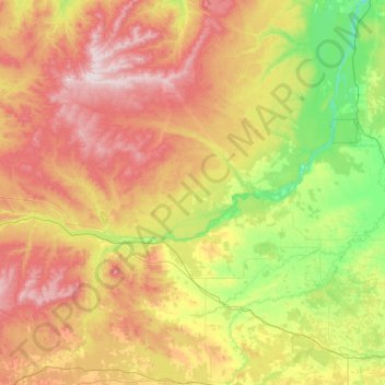
Name: Woodlands County topographic map, elevation, terrain.
Location: Woodlands County, Alberta, Canada (53.80293 -116.70229 54.85047 -114.22462)
Average elevation: 822 m
Minimum elevation: 558 m
Maximum elevation: 1,385 m
Other topographic maps
Click on a map to view its topography, its elevation and its terrain.
Canmore
Canada > Alberta > Division No. 15
Elevation Place opened in April 2013 as Canmore's new recreation facility. Construction of the facility began in 2012 to go alongside the Canmore Recreation Centre (the community's old facility). The facility offers an 8-lane 25m lap pool, a world class climbing wall developed by Walltopia, two cardio rooms, a…
Average elevation: 1,565 m