
Make a donation
Vigo topographic map
Click on the map to display elevation.
Make a donation
Vigo
Vigo has a transitional climate between the oceanic climate "Cfb" and the warm-summer Mediterranean climate "Csb" according to the Köppen climate classification. Although Vigo is the rainiest city in Galicia, with its noticeable drying trend in the summer, Vigo's climate is more similar to the variant of the oceanic climate commonly seen in the Pacific Northwest region of North America. The all-time record high for the city is 40.8 °C (105 °F) set on August 7, 2016. Vigo is known for its extreme rainfall in winter. December 1978 saw 925.6 millimetres (36.44 in) fall at the weather station in a single month. During that month on 7 December, 175 millimetres (6.9 in) fell on a single day. Normal values for 1991–2020 was 1,695 millimetres (66.7 in) falling on just 126 days indicating heavy rain to be common. The airport where values are taken is located further inland at a considerably higher elevation (261 metres (856 ft)) than the city itself located on the coastline in the Ria de Vigo estuary, which is likely warmer year-round.
Make a donation
About this map
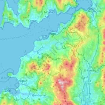
Name: Vigo topographic map, elevation, terrain.
Location: Vigo, Pontevedra, Galicia, Spain (42.13243 -8.91829 42.26470 -8.62703)
Average elevation: 124 m
Minimum elevation: -1 m
Maximum elevation: 697 m
Make a donation
Other topographic maps
Click on a map to view its topography, its elevation and its terrain.
Vigo
Vigo has a transitional climate between the oceanic climate "Cfb" and the warm-summer Mediterranean climate "Csb" according to the Köppen climate classification. Although Vigo is the rainiest city in Galicia, with its noticeable drying trend in the summer, Vigo's climate is more similar to the variant of the…
Average elevation: 121 m
Make a donation
Make a donation
Make a donation