
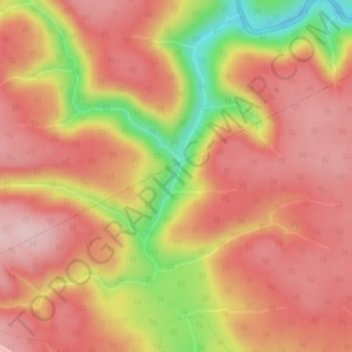
Ruisseau des Dix-Huit Milles topographic map
Interactive map
Click on the map to display elevation.
About this map
Name: Ruisseau des Dix-Huit Milles topographic map, elevation, terrain.
Average elevation: 294 m
Minimum elevation: 135 m
Maximum elevation: 377 m
Other topographic maps
Click on a map to view its topography, its elevation and its terrain.
Lac Chaud
Canada > Québec > Le Rocher-Percé > Chandler
Lac Chaud, Chandler, Le Rocher-Percé, Gaspésie–Îles-de-la-Madeleine, Québec, Canada
Average elevation: 4 m
Newport
Canada > Québec > Le Rocher-Percé > Chandler
Newport, Chandler, Le Rocher-Percé, Gaspésie–Îles-de-la-Madeleine, Québec, G0C 2A0, Canada
Average elevation: 19 m
Lac aux Outardes
Canada > Québec > Le Rocher-Percé > Chandler
Lac aux Outardes, Chandler, Le Rocher-Percé, Gaspésie–Îles-de-la-Madeleine, Québec, Canada
Average elevation: 61 m
Saint-Edmond-de-Pabos
Canada > Québec > Le Rocher-Percé > Chandler
Saint-Edmond-de-Pabos, Chandler, Le Rocher-Percé, Gaspésie–Îles-de-la-Madeleine, Québec, Canada
Average elevation: 313 m
Pabos
Canada > Québec > Le Rocher-Percé > Chandler
Pabos, Chandler, Le Rocher-Percé, Gaspésie–Îles-de-la-Madeleine, Québec, G0C 2H0, Canada
Average elevation: 9 m