
泌阳县 topographic map
Interactive map
Click on the map to display elevation.
About this map
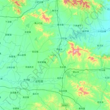
Name: 泌阳县 topographic map, elevation, terrain.
Location: 泌阳县, 驻马店市, 河南省, 中国 (32.56902 113.08931 33.16464 113.65049)
Average elevation: 197 m
Minimum elevation: 74 m
Maximum elevation: 925 m
泌阳县位于南阳盆地的东部,处在秦岭-淮河线上,属于暖温带大陆性季风气候,四季较为分明。县治在泌阳河之北,得名泌阳。泌阳县地处浅山丘陵区,地势中部高,东西低,山区面积占总面积的43%,平原区占16%,丘陵区占41%。全县海拔在83—983米之间,平均海拔142.1米。主要山峰168座,白云山主峰白茅堵海拔983米,为驻马店市最高峰,横亘县境中东部,北有罗汉山、五峰山,中部有双山、三山,南部有铜山、盘古山等。境内有河流25条,分属淮河和长江水系。其中泌阳河在境内长74公里,沙河在境内长66公里。
Other topographic maps
Click on a map to view its topography, its elevation and its terrain.