
Thank you for supporting this site ❤️
Make a donation
Make a donation
Banisilan topographic map
Click on the map to display elevation.
Thank you for supporting this site ❤️
Make a donation
Make a donation
About this map
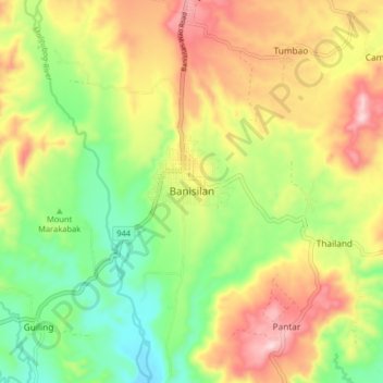
Name: Banisilan topographic map, elevation, terrain.
Location: Banisilan, North Cotabato, Soccsksargen, Philippines (7.46408 124.65463 7.54408 124.73463)
Average elevation: 392 m
Minimum elevation: 228 m
Maximum elevation: 593 m
Thank you for supporting this site ❤️
Make a donation
Make a donation
Other topographic maps
Click on a map to view its topography, its elevation and its terrain.
Thank you for supporting this site ❤️
Make a donation
Make a donation
Kidapawan
Located in Kidapawan is the Paniki Falls Eco-River Park located at Umpan Village, Barangay Balabag. Kidapawan is also one of the most well-known starting points for trekking on Mount Apo via the city's Lake Agco in Barangay Ilomavis, Kidapawan-Santa Cruz, and Kidapawan-Magpet trails which towers at 10,311 feet…
Average elevation: 494 m