
Thank you for supporting this site ❤️
Make a donation
Make a donation
Canots topographic map
Click on the map to display elevation.
Thank you for supporting this site ❤️
Make a donation
Make a donation
About this map
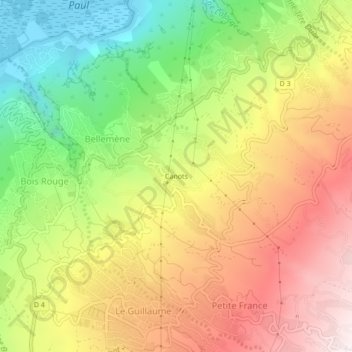
Name: Canots topographic map, elevation, terrain.
Location: Canots, Bellemène, Saint-Paul, La Réunion, 97460, France (-21.04298 55.28539 -21.00298 55.32539)
Average elevation: 491 m
Minimum elevation: 2 m
Maximum elevation: 984 m
Thank you for supporting this site ❤️
Make a donation
Make a donation
Other topographic maps
Click on a map to view its topography, its elevation and its terrain.