
Charlottenburg-Wilmersdorf topographic map
Interactive map
Click on the map to display elevation.
About this map
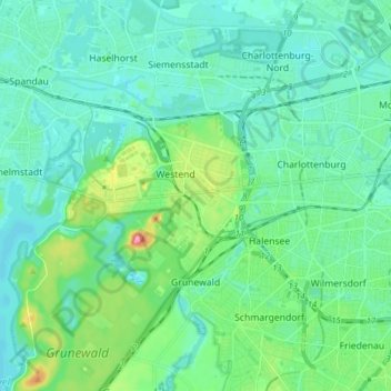
Name: Charlottenburg-Wilmersdorf topographic map, elevation, terrain.
Location: Charlottenburg-Wilmersdorf, Berlin, Deutschland (52.46646 13.18660 52.54943 13.34143)
Average elevation: 44 m
Minimum elevation: 26 m
Maximum elevation: 116 m
Other topographic maps
Click on a map to view its topography, its elevation and its terrain.
Steglitz-Zehlendorf
Steglitz-Zehlendorf, Berlin, Deutschland
Average elevation: 45 m
Marzahn-Hellersdorf
Marzahn-Hellersdorf, Berlin, Deutschland
Average elevation: 52 m
Friedrichshain-Kreuzberg
Friedrichshain-Kreuzberg, Berlin, Deutschland
Average elevation: 45 m
Wartenberg
Deutschland > Berlin > Berlin > Siedlung Wartenberg
Wartenberg, Lichtenberg, Siedlung Wartenberg, Berlin, 13059, Deutschland
Average elevation: 59 m