
岳阳楼区 topographic map
Interactive map
Click on the map to display elevation.
About this map
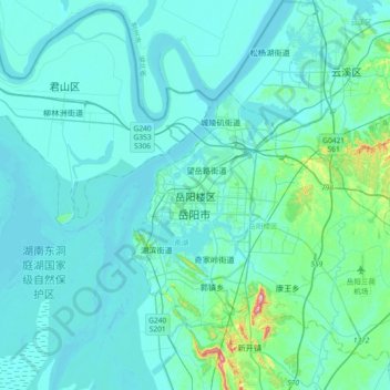
Name: 岳阳楼区 topographic map, elevation, terrain.
Location: 岳阳楼区, 岳阳市, 湖南省, 414000, 中国 (29.21411 112.96425 29.53411 113.28425)
Average elevation: 44 m
Minimum elevation: 17 m
Maximum elevation: 321 m
Other topographic maps
Click on a map to view its topography, its elevation and its terrain.