
Berchem-Saint-Laurent topographic map
Interactive map
Click on the map to display elevation.
About this map
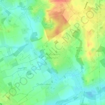
Name: Berchem-Saint-Laurent topographic map, elevation, terrain.
Average elevation: 46 m
Minimum elevation: 24 m
Maximum elevation: 82 m
Other topographic maps
Click on a map to view its topography, its elevation and its terrain.
Rattendaal
Belgique > Brabant flamand > Hal-Vilvorde > Leeuw-Saint-Pierre > Rattendaal
Rattendaal, Leeuw-Saint-Pierre, Hal-Vilvorde, Brabant flamand, Flandre, 1602, Belgique
Average elevation: 39 m
Leeuw-Saint-Pierre
Belgique > Brabant flamand > Hal-Vilvorde > Leeuw-Saint-Pierre
Leeuw-Saint-Pierre, Hal-Vilvorde, Brabant flamand, Flandre, 1600, Belgique
Average elevation: 42 m