
Zhuhai topographic map
Interactive map
Click on the map to display elevation.
About this map
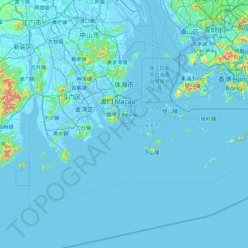
Name: Zhuhai topographic map, elevation, terrain.
Location: Zhuhai, Guangdong Province, China (21.66062 113.05819 22.48580 114.38888)
Average elevation: 22 m
Minimum elevation: -7 m
Maximum elevation: 916 m
Other topographic maps
Click on a map to view its topography, its elevation and its terrain.
Pubian
China > Guangdong Province > Fengkai County > Zhaoqing City > Jiangchuan
Average elevation: 43 m
Lianhuashan Park
China > Guangdong Province > Futian District > Lianhua Sub-district
Average elevation: 22 m
Tianchi (Heaven Lake)
China > Guangdong Province > Chao'an District > Fenghuang
Average elevation: 1,053 m