
Indian Springs topographic map
Interactive map
Click on the map to display elevation.
About this map
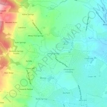
Name: Indian Springs topographic map, elevation, terrain.
Average elevation: 143 m
Minimum elevation: 94 m
Maximum elevation: 266 m
Terrain in the area is generally rugged with elevations between 600 and 1,900 feet (580 m) above sea level, the landscape being primarily wooded. The terrain here differs greatly from the neighboring Hagerstown Valley, where elevations average less than 650' and is characterized by fertile, gently rolling hills. While land for farming is not as readily available in the Springs area, orchards have been a source of local livelihood for centuries.
Other topographic maps
Click on a map to view its topography, its elevation and its terrain.
Rosedale
United States > Maryland > Frederick County > Frederick
Rosedale, Frederick, Frederick County, Maryland, 21709, United States
Average elevation: 100 m
Frederick
United States > Maryland > Frederick County > Frederick
Frederick, Frederick County, Maryland, 21701-4546, United States
Average elevation: 165 m
Villa Estates
United States > Maryland > Frederick County > Frederick > Villa Estates
Villa Estates, Frederick, Frederick County, Maryland, 21701-4546, United States
Average elevation: 103 m