
Dahmane topographic map
Interactive map
Click on the map to display elevation.
About this map
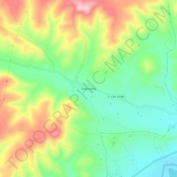
Name: Dahmane topographic map, elevation, terrain.
Location: Dahmane, Beni Ouarsous, Daïra Remchi, Tlemcen, Algérie (35.05782 -1.52821 35.09782 -1.48821)
Average elevation: 183 m
Minimum elevation: 93 m
Maximum elevation: 312 m
Other topographic maps
Click on a map to view its topography, its elevation and its terrain.
Sidi Bendhiaf
Algérie > Tlemcen > Daïra Remchi > Beni Ouarsous
Sidi Bendhiaf, Beni Ouarsous, Daïra Remchi, Tlemcen, Algérie
Average elevation: 275 m