
Groton topographic map
Interactive map
Click on the map to display elevation.
About this map
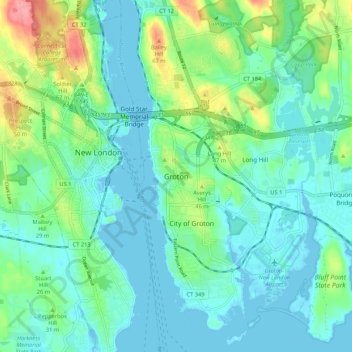
Name: Groton topographic map, elevation, terrain.
Location: Groton, New London County, Connecticut, 06340, United States (41.31016 -72.11620 41.39016 -72.03620)
Average elevation: 21 m
Minimum elevation: -3 m
Maximum elevation: 91 m
Other topographic maps
Click on a map to view its topography, its elevation and its terrain.
Groton Long Point
United States > Connecticut > New London County > Groton > Groton Long Point
Groton Long Point, Groton, New London County, Connecticut, United States
Average elevation: 2 m
Noank
United States > Connecticut > New London County > Groton > Noank
Noank, Groton, New London County, Connecticut, United States
Average elevation: 15 m
Poquonock Bridge
United States > Connecticut > New London County > Groton > Poquonock Bridge
Poquonock Bridge, Groton, New London County, Connecticut, United States
Average elevation: 20 m